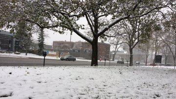
The Windsor-Essex region is expected to see some snow today and tonight.
According to the Weather Network, the region is estimated to see 5 centimetres, or approximately 2 inches of snowfall between Friday afternoon and Saturday morning.
Doug Gillham, meteorologist with The Weather Network, says since the ground is frozen that the snow will stick.
By noon Friday there's a 40 per cent chance of scattered flurries, with a 70 per cent chance of light snow starting at 4 p.m. until early Saturday morning.
Gillham says it will look like winter.
"So it's enough to coat the ground, and to cause some travel headaches. It's not a snowstorm like we have dealt with in the past, but it will - finally - look like winter when you get up Saturday morning."
He says the roads Friday evening may be messy.
"We will have steady snow through the evening, so if you have evening plans that's something to keep in mind. And the ground is frozen, so it won't be melting on contact with the pavement. If you get 5 centimetres in an hour that's a problem, but this is extended over the late afternoon, into the evening, into the overnight."
Gillham says the weekend won't be as cold as the week was.
"Some bands of Lake Effect snow in the snow belts is some flurries could extend into southwestern Ontario, but we wouldn't be looking at any accumulation during Saturday. And temperatures this weekend, a little bit more comfortable then what we've seen during the week, cold enough to get out and enjoy the snow, but not severely cold."
The region has yet to see a large snowfall this winter.
Gillham says temperatures will be back to being very cold next week.