The Northern Tornadoes Project is confirming that a third tornado did touch down in the Windsor-Essex region during recent storms.
On Thursday, the group shared that an EF1 tornado touched down in Cottam on August 24.
This comes after NTP confirmed two other tornadoes in the region on the same night, one along the west side of Windsor registered as an EF0 and another in Tecumseh registering as an EF1.
The Cottam tornado started just east of the end point of the Tecumseh tornado and is associated with the same storm.
The team investigated the area in Cottam after reports that several homes and barns were damaged, along with power poles and trees, and crops were damaged.
This third confirmed tornado had an estimated maximum wind speed of 145 km/h, track length of 13.8 kilometres and maximum path width of 670 metres.
An update to the Windsor tornado shows that the track length was 12.5 kilometres with a maximum path width of 580 metres, and an update to the Tecumseh tornado shows that had a track length of 22 kilometres and maximum path width of 1.05 kilometres.
Dr. David Sills, Executive Director of the Northern Tornadoes Project, says the Cottam tornado started where the Tecumseh one ended.
"That Cottam tornado had damage that was rated as high as EF1. It was also 145 kilometres an hour, the same as the Tecumseh tornado. This tornado was a bit shorter than the Tecumseh tornado, it was a maximum path around 14 kilometres as opposed to 22 kilometres. It had a maximum path width of 670 metres."
He says tornado activity across Canada is down in 2023, with the exception of a couple cities.
"There's two areas in the country that have seen multiple tornadoes, and that is the Windsor area and the Ottawa area. So, it's just bad luck on the part of those two areas that things keep happening there. I'm sure it'll be different next year."
He says the length and width of all three tornadoes was unusually large despite the low EF-scale rating.
"Usually with a tornado that long and that wide the strength of the tornado is stronger, we usually are getting into EF2 or higher. With the environment that was in place, with really high-end stability and we saw that with the amount of lightning and the amount of rain that was with these storms, we're fairly lucky these weren't stronger tornadoes."
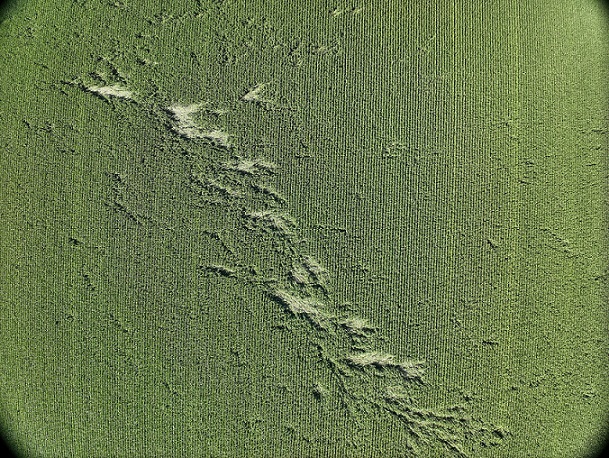
Drone image of crop damage along the path of the Cottom tornado. The directions of the fallen corn stalks show evidence of cross-path winds, and subtle curvature, associated with the cyclonic tornado. The tornado was moving from the top-left of the image to toward the bottom-right. August 31, 2023 (Photo Credit: Courtesy of the Northern Tornadoes Project)
Dr. Sills says the NTP wouldn't have known about these tornadoes if the public hadn't shared damage photos and videos on social media.
There were signatures on radar that showed there was a rotation that may have gone through, and reports started coming in from the public.
He adds that it's important that data, in the form of photos and videos, gets sent in from the public during storms like the one on August 24.
Lastly, he adds that while most people think the tornado season is wrapping up with the end of summer nearing, he says warm temperatures are expected this fall which could mean more tornadoes in the region.